Wednesday, September 30, 2015

Soldiering On

Day 10: Reeth to Richmond
Miles today: 14.42
Total mileage: 130.81

Once again Jim and I thought we would have an easy day but it ended up being a challenge. Right as we were leaving Reeth we ran into Stuart, a guy who had been fishing that morning in the River Swale.  He showed us the brown trout he'd caught, then showed us pictures of some of his prior catches.


When we told him we were headed to Richmond he told us there were two ways to get there, one along the river and the other up along the hills. He said if it were him he'd go along the river on such a nice day. He told us we'd be in Richmond by 1 pm, suggested a restaurant there, and we parted ways.

We debated going the river route but with our navigational issues we were hesitant to deviate from our instructions and maps. What a mistake. Sometimes following Wainwright's path is like a Family Circus cartoon. You go up, around and over instead of taking a direct path. Several times we've walked for miles only to cross a road and see a sign for the town we just left only a couple or so miles away! We had walked almost nine miles from Reeth when we saw this one:


The terrain is getting flatter though, since we crossed the Pennines, and while we're still climbing hills they aren't as high as ones earlier in the trip.

A good part of the walk now is on permissive paths through pastures. You always have to make sure you're on the correct side of the fence so you don't walk through a huge field only to find out there's no gate or stile to get out. That happened to us today. Then when I went up to a stone fence to see if it was low enough to climb over, I walked into a nettle bush and my legs burned like crazy for awhile. Like I've said before, each day brings new danger.

We're so grateful for our GPS though. I downloaded the OS (Ordnance Survey) map and have the C2C overlay so we can pinpoint within about a foot if we've gone off track. It is amazing, but you have to check it constantly (which slows you down-- a lot!).

The other thing we dealt with today was cows. Mostly we've been walking through sheep pastures until now. There were lots of cows today, though and we had to be very careful not to get between a mama and her calf.

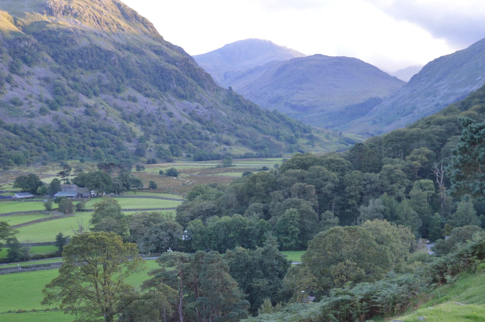
Along the way we saw beautiful vistas like this:


and this:


We even saw this:


It's a little adder snake sunning himself on a rock.  The guidebook says you will be lucky to see an adder in England, so I guess we're just lucky!

We trudged along and finally saw Richmond Castle in the distance around 3 pm. About a half hour later we had descended the big hill and walked into Richmond, the biggest city on the whole C2C--about 8,000 people!


Fighting Fatigue and Frustration

Day 9: Keld to Reeth
Miles today: 15.71
Total mileage: 116.39

The guidebook says "This option adds up to about 4-1/2 hours of level walking (11-1/2 miles) and you may well end up in Reeth soon after lunch." Lunch must have been a typo and he must have meant tea time because we walked into town shortly after 4 pm. And once again, the guidebook mileage was way shorter than the actual miles. It's very frustrating because you're thinking you've got only 5 hours or so of walking and then it ends up being seven or more. We're having a hard time planning our days because of the additional walking time. Sometimes we would like to stop in a little town and take a look around but time simply doesn't permit.

There were two route options today. The first was higher and followed a ridge while the other was along the River Swale. The low route passed by the charming little town of Muker. Rumor has it that Muker was a favorite of James Herriot. Having read all of his books, I thought it might be worth a stop.

Approaching town we heard music playing and as we got closer we realized it was live and coming from the public hall. Coincidentally we ran into Chris, the proprietor of the B & B in Keld and he told us it was the Muker Silver Band and they play all over the world. What a stroke of luck to hear an impromptu concert! We spent a little time taking pictures, had some tea and hit the trail again.


The first part of the walk was very pretty and we saw thousands of pheasant, partridge and grouse. They were everywhere! We walked along the river bank and were making pretty good time.


Then, it was back up onto a hilltop and through what the guidebook described as woods. It was actually overgrown brush and it seemed like we were fighting our way through the Amazon. Like I said, there's a new adventure every day! Jim said they should do what the Americans would do--bulldoze it and put in a snowmobile path. It sure would have made walking easier!

The rest of the day was pretty, but it got to be a bit longer than we anticipated. In the end, when we finally did reach Reeth, Mark and David were sitting outside the pub having a pint and soon Andy and Joe from the previous night showed up. It's fun to see everyone at the end of the day and regale the day's walk over a beer. All agreed, the walking got long today and seemed like it would never end. It seems everyone is having some fatigue.

We had dinner, then went back to the pub where Mark and David joined us to watch the Rugby World Cup. It was a big match since England played Wales (kind of like the US playing Canada in hockey). Our friends were pulling for England but unfortunately Wales pulled ahead near the end of the match and won. We don't even pretend to know how rugby is played (and don't know the difference between Rugby League and Rugby Union) but it was fun to watch.

We're going to Richmond tomorrow and will have a rest day on Monday. Mark and David are pressing on and are going a few miles beyond Richmond so it's very unlikely we'll see them again. Kind of sad, but we exchanged email addresses and hope to keep in touch.

A couple of pix from another lovely day's walk!


Sunday, September 27, 2015

We're In Deep

Day 8: Kirkby Stephen to Keld
Miles today: 15.16
Total miles: 100.68

For what it's worth, the guidebook said that today will be a 13.5 mile day so we tried to get little earlier start, knowing it wouldn't be an easy 13.5 miles. So at 9 am we set out of Kirkby Stephen. It is a cute little town and once again there was bright sunshine and clear skies so we stopped to take a few pictures but didn't dawdle because Nine Standards Rigg was looming ahead. Nine Standards is a group of nine man made rock formations high on top a hill. The peak is a five mile walk uphill from town.

Right as we approached the hill a man came bounding by us and said he was making his ninth C2C crossing but this time was doing it in a leisurely 10 days instead of his usual 8 or 9--he just doesn't have enough daylight hours this time of year to make it in less. 

He went on to tell us that his name is Albee and he used to work on the oil rigs, smoke 60 cigarettes a day and drink too much. His doctor told him he would die soon if he didn't change so he started walking...and walking...and walking. Then he was off, saying he might see us at the top because he was stopping up there for his coffee and bacon roll. We figured he would be long gone before we got there. Albee is a C2C legend so we were happy our paths crossed.


Nine Standards is a bit problematic because of the bogs on the descent. There are three routes; the green where you avoid the peak and kind of skirt down the side or the blue and red which split off from the top. I wanted to take the green route to make a slightly easier day but I knew Jim really wanted to go to the top. It was a gorgeous day and people told us you can see all the way back to the Lake District so to the top it was.


By the time we got to the top it had become cloudy, with a strong bitter wind. We rested a bit then started down. NOTHING could have prepared us for the bogs. Nick, the proprietor at the B & B told us to never step on the bright green grass as it was growing in water and the ground was not firm.


We had to test Every. Single. Step. with our walking poles to make sure we were stepping onto ground and not into the bog.


At one point, I was leaping to a bank but it wasn't solid and the next thing I knew I was thigh deep in muck. Fortunately I was able to extricate myself very quickly. Sometimes this goo will suck your shoes off and you have to leave them or dig them out. It was still awful and you can imagine what this smells like with the hundreds of sheep grazing up there. Yuck!


There was no alternative but to press on. It was a painstaking descent and very stressful. Finally, after eight miles of bogs, we were on firm, dry ground. As with other parts of this trip, once you've completed a particularly rough patch, something beautiful comes along to make you forget about it and this time it was the River Swale. Our final couple of miles were along the banks and we found out we'll be more or less following it the next few days. Sounds very peaceful!


Finally, we reached Butt House, our Keld B & B.  It is iconic along the path. Keld is significant for a couple of reasons. First, it marks the halfway point of our journey and second, we've crossed the Pennines from Cumbria into Yorkshire.

At dinner, there were nine of us; five doing the C2C, two doing the Pennine Way (the north/south trail across England) and two day walkers. It was a fun evening with everyone telling stories about their walks and future walks. Two of the C2C guys are from the Peak District and told us we "have" to visit there because of all the beautiful trails. I thought they were saying "Peat District" and didn't want any part of that!!


Friday, September 25, 2015

Over Hill, Over Dale

Day 7: Orton to Kirkby Stephen
Miles today: 14.91
Total miles: 85.52

Jim and I had a very nice stay in Orton at the Barn House. One thing we didn't count on was how late we would start every morning. Since we're both early risers we figured we'd get up, have a quick breakfast and be underway. That's not the case though. Breakfast is typically served between 8 and 8:30 and is a three course affair. First is fruit and cereal, then toast and jam followed by cooked breakfast. A full English breakfast consists of eggs, bacon, sausage, mushrooms, tomatoes, potatoes, baked beans and black pudding (don't ask!) Jim usually has everything except the black pudding and I have tomato and mushrooms and maybe some beans. We aren't used to such hearty breakfasts!

 This morning we took even longer because we were talking with another couple, Ruth and Mike, who are doing the C2C east to west. We were surprised to find out they have been to Door County. They are the first people we've met who have really even heard of Wisconsin. Usually, we tell them it's north Chicago and then then they have some idea. Everyone else we've met who have been to the USA has been to Florida (Disney) or New York.

Anyway, their daughter's husband is studying in Chicago so they had been for a visit and were telling us how much they liked Door County. Then they said they had come in December! Too bad they didn't see it at its best. We told them to come back in spring or fall when it is really pretty, not the cold, gray winter.

Finally we were underway by about 9:15 and walked up the road to catch the trail. As we approached, cars pulled up and a group of people got out. It was the church group we met before. Seven of them are walking and they have a house rented in the area that they are using as a base. They then walk the trail and get a cab back to their car. We had walked with them a couple of times and it was good to see them again.

Today's walk was very hilly, but no strenuous climbs. We were mostly walking through pasture lands so it was easy on the knees and joints. It started out chilly, but with bright sunshine. At 11:00 that changed and a storm blew in complete with rain, sleet and high winds. We donned our rain gear and carried on.

We walked with the group off and on throughout the day. They're all telling us our next walk *HAS* to be the Camino Way. They talked on and on about it and even told us about stopping in the "hippie" shop and the brownies they got! They are very entertaining.

By 3 in the afternoon, we strolled into town just in time for tea. Today was our fastest pace yet.

After checking in at the B&B, we had dinner at The Mango Tree, an Indian restaurant. It was a nice change from pub food, but we stopped by the pub afterward and met up with our old buddy Mark. He was with David, another walker he met at the campground.  I hope they can walk together because I fell kind of sorry for Mark continuing on his own after Ray dropped out.

We hoping for a good night's sleep because tomorrow starts with a 5 mile climb!

A few pictures from today-they don't begin to do justice to how pretty it really is.


miles and miles of stone fence:


No one here but us sheep:


The church group after the walk.  The one man is looking up at the hundreds of teacups hanging from the ceiling.


Wednesday, September 23, 2015

Taking It Easy

Day 6: Shap to Orton
Miles today: 10.18
Total miles: 70.61

Jim and I started this morning with a leisurely breakfast, knowing that we didn't have far to go today. We've found, though, that breakfast is always leisurely here. Today we weren't in a hurry and had a nice visit with Jeff and Hilary, and Laura, another woman who was staying at Brookfield House. This will be the last day we see Jeff and Hilary as they, too, are going all the way to Kirkby Stephen. We will be a little sad to leave here as Margaret has been such a lovely host, but she checked the tag on our bag and has assured us the place where we're staying in Orton is "lovely."

We got underway at 9:15. Many of the public footpaths in England are through fields and pastures. You always have to make sure you are on the right side of the fence (stone wall) so you can get out. First thing, we found ourselves trapped and had to backtrack to get on the other side so we could climb out the style.

The walking was easier today. The guidebook says it is a flat walk, but again, flat in Wisconsin is FLAT, where here it just means the hills aren't quite as high. We hadn't been walking long before we saw this:


It was Asad.  We hadn't expected to see him today.  The other man is Rod, who has walked the coast to coast several times. We weren't exactly sure of his story, but somehow he found himself in some deep water the previous day and had lost his maps and compass and was trying to get to Kirkby Stephen to replace his shoes.  We always feel better when people who are familiar with the area still find navigation difficult.

This part, though, was much better way-marked.  Now this is a cairn!


Hard to miss this, unlike some of the little tiny ones in the lake district.  Occasionally, there are even signposts.


Around noon, we topped a hill and could see Orton in the distance.  As I was walking down the hill, it was an almost surreal experience. I was thinking to myself, "Here I am, in England, just walking, surrounded by all these beautiful sights." It was a powerful moment.


It was overcast most of the day and as we got into town it started misting.  We made our way to the Orton Chocolate Factory and ran into Jeff and Hilary leaving there. They left Margaret's while we were still having breakfast so maybe we're not that much slower than everyone else after all.

Margaret was right about The Barn House, our B & B here in Orton.  It IS lovely!

We walked down to the pub for dinner and in walked Mark.  He came over and said that sadly, Ray had fallen and hurt his back.  He went back home just before Shap, but Mark planned to continue alone.  We offered to buy him dinner but he said he had already eaten and was just going to have a pint of beer and plan his route. Ray had been the planner so now Joe was trying to get his bearings. They were carrying heavy packs with camping gear so I'm not surprised Ray lost his balance.  I fell and had only a 10 pound pack.  We may not see Mark again on the trail.  He is trying to tack on a few more miles everyday and has a little more flexibility by camping.  I hope he makes it!


Leaving the Lake District

Day 5: Patterdale to Shap
Miles today: 10.3
Total miles: 60.43 (about 1/3 of the way!)

It was another beautiful day and this was the first day we were outside of the Lake District.  The good thing about that? NO ROCKS. We were walking through fields and along country roads--what a relief on our joints and feet!

The best thing about today was that we would walk through a field, over a little hill, then down in a valley and unexpectedly come across something like this:


or this:


It was delightful and exactly what we were looking for in a walk.  Shap Abbey is near where we are staying. It sits down pretty far in a valley and even Jim started feeling a little fatigued walking back up the long hill into town.


We came into Shap on the north end and made our way down to the end of town to Brookfield House B & B where we met Margaret.  She is quite a character and has the perfect job for her personality. We got quite an interrogation about our bag.  When we checked it in at the airport it weighed 49.5 pounds. We've taken some things out and now it weighs pretty close to the Sherpa Van limit of 20 kg (about 44 pounds).  She thought we might be over the limit! I can't imagine that she had actually lifted the bag. She chatted on for a few minutes, showed us to our room, then told us she had scones in the oven so we should come down to the lounge in 10 minutes for tea and scones.  How very English!

When she brought the tea items, all were in beautiful matching rose patterned China cups, saucers, teapot, and plates.  She even had coordinating, freshly ironed, embroidered napkins.  It was almost too pretty to use.  As we were having tea more guests came to the door.  We were surprised to see Jeff and Hilary, a London couple we had met in Ennerdale Bridge.  We spent a few minutes catching up on each other's walks, then parted for evening meals.

We walked down the block to the pub and had just ordered food when our friend Asad walked in. We hadn't seen him during the day so we weren't sure whether or not he was able to continue.  The pharmacist in Grasmere had recommended a product called Compeed for blisters and he said it worked very well so he made it the entire way today.

We had a nice meal with him, exchanged contact information and said our goodbyes. He is going all the way to Kirkby Stephen (21 miles) tomorrow while we are breaking that leg into two days and stopping in a little town called Orton.  Supposedly it is an easy, fairly flat stretch, but 21 miles is still a lot to do in a day.  Even if they had a moving sidewalk all the way there I'm not sure I could walk that far in a day.

A couple more pix from today:


You're Going The Wrong Way

Day 4: Grasmere to Patterdale
Miles today: 5.62
Total miles: 50.13

A couple of days ago we ran into a couple of English guys near Black Sail Youth Hostel. As we were heading out of Grasmere, they were heading into town. After a little discussion, they realized they had been going the wrong way so they turned around and started back up the hill with us. That's right, the day started out with another big climb.

As we walked along we visited a bit with the two guys who we learned were Ray and Mark. They are the ones who are doing the walk and camping. They had gotten wet the night before and were cold and soaked through. I asked why they decided to do the hike and Mark said "too much to drink one night." I guess that's as good a reason as any. They were from the Leeds area and really seemed to be nice guys. Ray is married with kids, but Mark has never been married. He said he'd been engaged twice but got cold feet both times and backed off. I told him in that case I would not introduce him to my daughter.

As we were walking, it was pouring rain. Buckets of rain. I couldn't see anything. As we started climbing higher, Ray and Mark went on ahead of us. I was very sore from falling the day before and was feeling a bit discouraged. Just awhile later, I asked Jim why we were doing this. Here we were in one of the prettiest areas of England and we were wasting our time slogging up the hill in the rain. By the time we would arrive in Patterdale we would be too exhausted to do anything. So we went back down the hill and looked up the bus schedule.

After we were on the bus for a bit, the weather turned nice and we had a beautiful tour. At the bus stop we were chatting with a local couple. They sat behind us and explained everything we were seeing. It was great.

We had to go to Patterdale via Penrith and when we arrived another man came up to us and said he had overheard we were going to Patterdale and that we would have a wait for the next bus. He suggested a nearby cafe and as we were in line at the cafe, he came running up to give us a bus schedule. We are overwhelmed by how nice everyone is.

Penrith is a nice town and we wish we had more time to look around. We had to catch the bus, though, so will have to go back another time.

It was a gorgeous bus ride around Ullswater (a huge lake) to Patterdale. When we walked into town we saw our German friend from a couple of days ago and he said Mark and Ray had just come through. The German guy's name is Asad and we were glad to see him. He was having a terrible time with blisters and we thought maybe he cut his walk short. He did what we had done though, gotten a ride to Patterdale. He caught the Sherpa Van and didn't walk at all that day. We ended up walking almost the same number of miles as we were supposed to...just in a different direction.

Asad was staying at the same B & B as us so we had a beer with him that night.  We didn't see Mark and Ray tonight but hopefully we'll catch up with them later on the trail.

Photos from today--not too many because it was raining too hard when we were walking.


We stayed at The Old Water View tonight.


Supposedly it was one of Wainwright's favorite inns along the path. Probably because of this view.


Butt-Kicking Day

Day 3: Seatoller to Grasmere
Miles today: 13.5
Total miles: 44.51

The walk today kicked my butt--literally. We left Seatoller and walked toward Stonethwaite. We tried to take a little shortcut but turned the wrong way and had to turn around. Fortunately, we quickly realized our mistake and only lost a few minutes.

Once we found our way again we were walking along a beautiful stream. There were waterfalls and a nice path but it didn't last long.


Soon it was a climb straight uphill.


We are finding it particularly difficult to stay on the path. We are using a guidebook, map and GPS but still have to constantly stop to make sure we're still on track. The Coast to Coast is not way-marked through the Lake District. The biggest clue you will find are little piles of rocks called cairns, but they are few and far between.

We would climb a ways thinking we were near the top but there was always another summit. Nothing we have indicates where the top really is.  We climbed to Lining Crag and then to Greenup Edge before we reached the top.


After reaching the top, the guidebook had all kinds of warnings about not getting on the wrong path on the descent, but of course we did. Luckily we ran into someone and when we asked if he was going to Grasmere he said "No, Wythburn." We were able to get a GPS signal and see that the path we needed was just a short distance away.

In hindsight we maybe should have stayed on the other path. By this time there was a misty rain and a steep rocky path down. We went down, down, down and down some more. Streams were everywhere and we would cross them time and time again. We started worrying about running out of daylight so we're trying to move quickly down the hill.

We had hiked over six hours and saw NO sign of civilization except for a handful of other hikers going in the opposite direction and the guy going to Wythburn.

I was trying to be careful but ended up falling THREE times on the way down; twice on my backside and once face first. I was really lucky, though. No serious injuries, just lots of bruises.

We finally saw a sign for the public footpath to Grasmere and made it into town. Ian, the B & B host, was at the end of the lane waiting for us. What a welcome sight!

We got settled in, showered, then off to the pub. Another long day.

Language Barrier

Day 2: Ennerdale Bridge to Seatoller
Miles today:  18.15
Total mileage:  31.01

We got a little bit of a late start today because we waited for our luggage to be delivered.  We knew the terrain would be a little more challenging so we wanted our poles and proper gear. It was 9:30 before we got underway.

Our guidebook listed today's walk at 13 miles.  By the time we got to the B & B we each had 18 miles on our Fitbits.  During our preparation I read several blogs that said mileage and the time it takes to walk it is vastly underestimated in the guidebooks.  We are finding that to be true. It took 9 hours of almost constant walking today.  Parts of it were not fun.  The good things were beautiful weather again and gorgeous scenery.  We started out by walking the first few miles along the (very rocky) shore of Ennerdale Waters.


The next few miles were on a fairly flat easy trail along the River Liza.  We followed this trail all the way to the famous Black Sail Hut Youth Hostel.


We were feeling pretty good about the day's progress and had met up with our German friend again. Right before we got here we met two English men who were also doing the C2C and camping.  That's really rough. They were nice guys and the five of us left the hostel at about the same time. Obviously we were overconfident about our walk to this point because the next phase would be over Honister Pass. I took one look up and said "You've got to be kidding?" It was a long, slow trek up the mountain and sometimes I would only walk 100 steps before I had to stop and catch my breath. Once we got to the top and looked back down, I couldn't help but cry over how beautiful it was.  What a reward!


Unfortunately, I was soon crying for another reason because the walk up was a piece of cake compared to the walk down. The trail followed an abandoned (in England they say "disused") mining road.  It was treacherously rutted and rocky.  Every step was an ordeal but we finally made it to the bottom.  After that it was much easier walk downhill into Seatoller.


When we arrived at 6:45 Christine, the proprieter at our B & B, told us if we wanted to go for an evening meal, she would run out and stop the bus that was pulling out next door while we put down our backpacks.  She said the pub was about a mile away and we should take the bus over then she would pick us up at 8:00.  So we ran to the bus, paid the fare, and told him we wanted to go to the Scafell Hotel.  After about 10-15 minutes on the bus, we wondered where we were going.  Finally the bus stopped to pick up another passenger so we asked the driver if we missed the Scafell Hotel.  He said, "Oh, I thought you were going to Keswick. All you can do now is go over to the hotel across the street and call a taxi to take you back."  No apology or anything. We called the cab (which had to come from Keswick) and waited for a ride back.  The silver lining was that the cab driver was a delight. There was a beautiful red sky sunset and he said, "I've lived here for 58 years and I can still see things and say 'Wow'."  Down the road a ways he pointed out the window and said "Look at that bit of fog on the field.  It looks just like a ghost." And it did.

By the time we got to the pub we were too tired to eat, so just tried a pint of the local ale and waited for Christine.  It was a long day.

Monday, September 21, 2015

Tally Ho!

Day 1:  St. Bees to Ennerdale Bridge

After leaving Abbey Farm, our lovely bed and breakfast in St. Bees, we were ready to head for the coast.  Since we've been here we've learned that distance means something entirely different than what it does to us.  Steve, our host at the B & B told us that the coast was just up the road.  A little over a mile later, we were there. Unfortunately, it was low tide so we had quite a walk down to the water for the traditional C2C rituals:  dipping our our boots into the Irish Sea and picking up a pebble to carry to the North Sea (I got a VERY small stone!).


Then we were off.  The walk starts with a climb up to a ridge and the first few miles follows a path along the Irish Sea coast.  We were blessed with an absolutely gorgeous day; temperature around 60, sunny and nearly cloudless.  Just beautiful.


After leaving the coast we walked through the little town of Sandwith, then onto Moor Row and Cleator. We met up with a German fellow who seemed to have as much trouble finding the route as we did.  The C2C is not a national trail so it is not way-marked. We have a book with hand-drawn directions, a map and GPS but it is still easy to lose the way. We walked with him for awhile, then he went on ahead of us.

It seemed we were walking at a pretty fast pace, but we still had about three miles to go to Ennerdale Bridge.  We hadn't stopped for lunch, were tired, thirsty and getting worried about running out of daylight. We asked someone in Moor Row about a tea shop or pub that might be open and he directed us to a hotel pub a couple of miles down the road past Cleator.  We stopped in and the young woman at the front desk said they weren't serving meals at that time (typically pubs here serve from about noon-3 and then from 6-9). We said we were just looking for a beer so she cheerfully opened the bar and served us a pint.

After this little break we made our way the last couple of miles to Ennerdale Bridge--by cab!  Our guide book said it was a 14 mile day and both our Fitbits showed over 14 miles so we didn't quibble about how we got the miles!

As we checked in at The Shepherd's Arms the proprietor told us she had some bad news about our bags.  They were not to be delivered until the following morning. What a disappointment.  We knew there would be a lot of hill climbing and it would be extremely difficult without our hiking poles.

Luckily the pub was right inside the hotel so we didn't have to go out for dinner. After a nice meal and a couple of beers we collapsed into bed.

A few more pictures from the first day's walk.